

How can quarrying approaches be brought into the 2020s?
In 2014 I was working as the mine manager of a raw materials extraction operation for a major cement plant. During this role, I was continually frustrated by the lack of geospatial and geomining data relating to the operation. Simply put, the information required for efficient decision making was either unavailable or out of date. For example, site surveys would be, at best, annual and, in most cases, out of date before even received on site. To compound this, much of the information that could be available was tied up with different consulting groups, which meant that in each instance, I had to guess who might have the data and then pay to access work that the company had previously commissioned.
From this experience, I realised that if I was running into these types of issues, many other mine managers around the world would be in a similar position. By reviewing the situation, I realised that I needed:
1. Regular, up to date surveys and aerial photography;
2. Methods to visualise the site and conduct short term planning without recourse to external parties;
3. A sound geological understanding;
4. An optimised mine design that considered the costs of, and revenue from, extraction;
5. A robust mining schedule to determine the correct extraction sequence to meet plant requirements;
6. Knowledge of and access to all relevant, up to date geomining reports, licenses and approvals.
In short, it was a big ask and certainly one that went largely unanswered during my tenure. This said, I decided to make it a personal mission to solve these problems and from this action list, Cement & Aggregate Consulting was born.
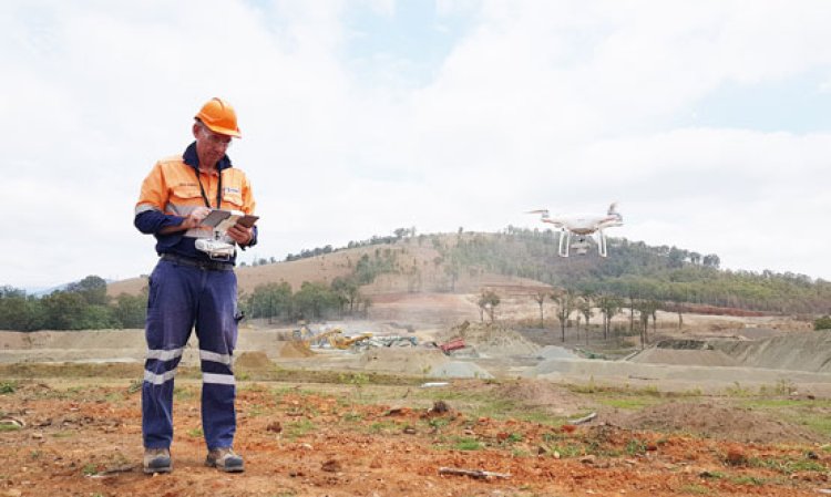
In 2017, something occurred that allowed me to start on the journey to the realisation of my goals. It came in the form of exposure to an Australian company called PropellerAero and resulted in being able to tick off the first wish on the list. The combination of the PropellerAero photogrammetry platform and simple, cost effective drones from DJI led to cheap, reliable and timely survey and aerial photography.
The PropellerAero platform also allows non-technical users to measure volumes, distances and areas and has evolved into a superb visualisation tool, one used at sites around the world to plan and collaborate with stakeholders. Over the ensuing three years, this functionality has continued to increase to the point where my team now find it invaluable.
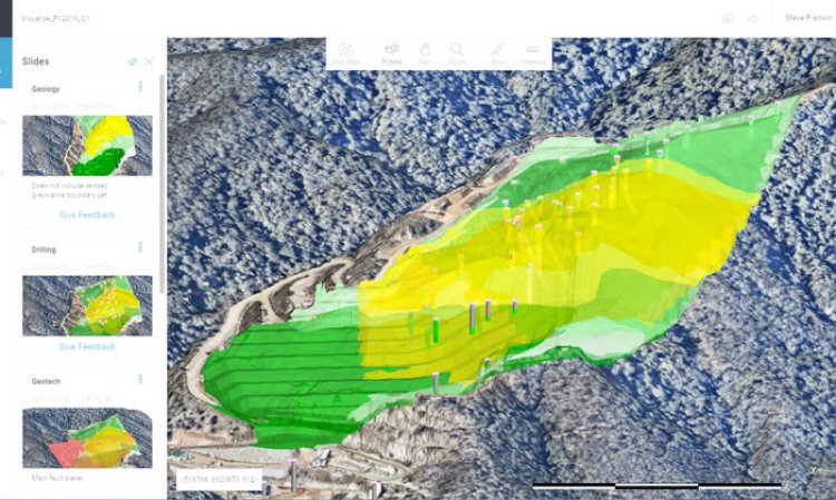
The next area of investigation was geology. There surely had to be better ways to understand and model limestone deposits than with the then ‘industry standard’ tools I had been exposed to. Around this time, we became aware of Leapfrog, an implicit geological modelling tool. One of the primary benefits of this tool is that once a model is set up, the addition (or adjustment) of data becomes incredibly simple and the model will automatically re-run without laborious manual editing. From this, it was then relatively easy to explore, model and reconcile raw material models. It also allowed us to create web-based models that could be shared with other stakeholders; yet again bringing technical data out of expensive, specialist software (and consultants) and into the hands of operational decision makers.
My experience was that most sites have only a limited understanding of what the correct depth and shape of their extraction area should be. In many cases this is determined by available land and/or expected overburden stripping requirements. My thought was that there had to be a better way.
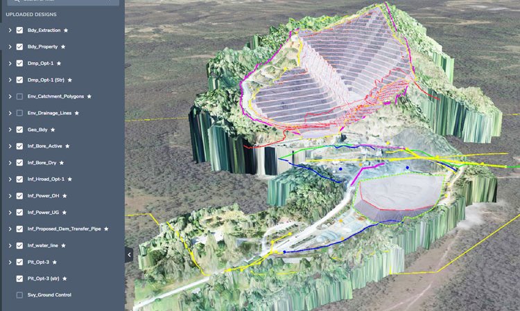
With sound geological modelling in hand, we investigated the use of pit optimisation techniques to determine the mine plan. Around this time, we had encountered the Deswik.Suite mining software. This is an integrated mine optimisation, planning, scheduling, haulage and rehabilitation platform. Of note in this instance was the mine optimisation module. Mine optimisation involves taking the cost and value of each mining block and using mathematics to determine the correct pit shells based on financial parameters. This approach was first brought to industry notice through the Geovia Whittle software. More recently advances in algorithms have resulted in better and faster results, while the integrated Deswik approach ensures that it is very easy to quickly move data in and out of the system and update it as changes are needed.
With an effective system to create a pit shell that we knew was economically sound, mine design can follow. Not only does optimisation provide an optimised pit shell, but it can also help to provide the pit shells by year (or other period) to help inform scheduling and ensure there is a clear view of stripping and development requirements.
With a sound geological model and an economical pit design, it is then relatively easy to use a scheduling package to determine the best way to extract the deposit, while the use of integrated haulage software can help to determine how many trucks are required and the amount of fuel they will consume.
Lastly, integrated environmental software can ensure that water management is effective, and that rehabilitation is planned and carried out in a timely and effective manner.
In summary, we found that a combination of products from PropellerAero, Leapfrog and Deswik resulted in a cost effective and well-integrated technical solution once we had fully learned how best to integrate the platforms and had designed and tested documented and repeatable workflows.
Document access has also been an interesting area to address. Probably one of the best solutions on the market these days is Google G-Suite. Simple, easy to use and with data accessible on and off-line, G-Suite is a viable way to ensure that everyone has access to all relevant data when they need it. This is a great way to ensure that there is that ‘one single source of the truth’ that people often talk about. What I have found however, is that pulling all this data together can be a task of almost Herculean proportions. Between crucial data stuck in personal files, emails, paper archives and plans, the collection, validation, scanning and conversion of old reports to searchable electronic documents can take some time and effort. It is, however, an effort that has proven very worthwhile.
Interestingly, a requirement I had not really considered in my six point ‘wish list’ was how we were going to ensure that the designs that were created could be applied on the ground. At the time, we did not have any survey equipment and relied on external surveyors. This was only partly workable as, once again, we had to rely on an external party and any survey that was laid down was easily lost during operations.
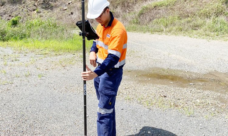
A primary step towards resolving this issue was finding the low-cost, high-accuracy GPS survey device by Trimble. For approximately a tenth of the cost of traditional GPS rovers, this device allowed us to easily lay out a design in the field and pick up new survey data as needed (e.g. new services that were laid down etc.)
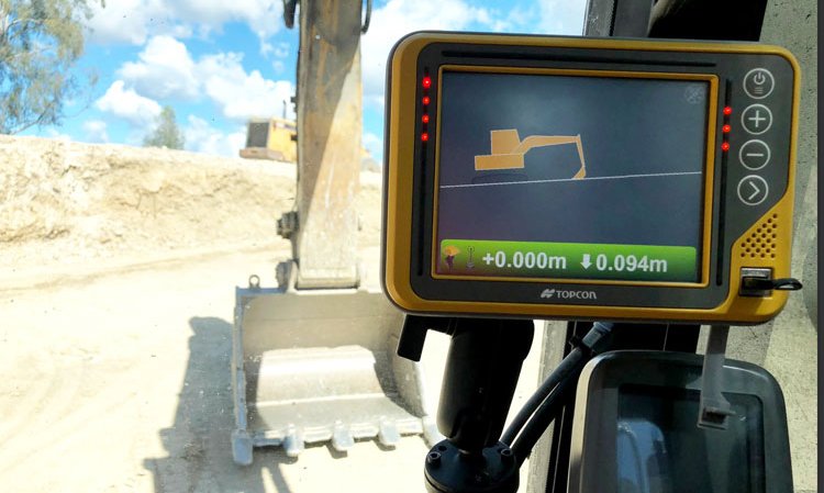
A further development in this area has been the greater availability of GPS machine guidance systems for loading tools and hole navigation systems on drill rigs. Both these types of systems provide the opportunity to ensure greater compliance to plan with less survey input.
An additional and new development has been the rise of augmented reality devices that can further help to visualise designs in the field. Yet again, Trimble is a leader in this field, and we have been trialling two different approaches to this technology. Ultimately, we see this as the next major technology pivot and are working on a range of applications to enable this.
While the above summary can give some sense of the broad systems and approaches taken, the investment in time and effort to work this all out from scratch should not be underestimated. Our goal in doing so was to determine workable software systems and workflows and then determine ways to put these in the hands of our partners so that they are able to run a majority of these processes themselves. This has been no minor undertaking! We are always happy to field questions from those in the sector who are interested in this approach.
The age of the ‘digital quarry,’ one that utilises cost effective hardware and software solutions to empower stakeholders to make good decisions, remove people from harms’ way and make a significant difference to how we do business, is firmly upon us!


